Showing posts with label car. Show all posts

Monday, February 22, 2016

Sunday Safety Watch: 02/07/2016 to 02/20/2016


Disclaimer: So, first I apologize for how long it's taken to get this up, The Crime Reports Website was down for much of January. I did talk to the director of Media Relations at a public safety meeting and tell our neighborhood resource officer, they weren't aware it wasn't updating. Just a reminder these are trends, and the presence of crime in one area in the past doesn't guarentee it will reappear in that area in the future.

The map above spans two weeks. You will notice all the patterns are weak, hence the pink lines. The darker the arrow, the stronger the trend. First off, not much is happening according to the map in February. It does appear assaults and property crime [graffiti] are on the rise. They seem to weekly trend up from Cherry towards 14th Street and Gundry. Josie and I did a patrol through the neighborhood pretty late into the night, and it was rather quiet.

A Go Long Beach Run through the area showed Gang tagging is up. In response, we hit several areas outside the neighborhood with Go Long Beach. We also used Code Enforcement with businesses that refuse to take the tagging down. - See the Neighborhood Expansion Report Below


There is also a week trend of assorted crimes along Spaulding in the East end of the MacArthur Park Neighborhood of Central Long Beach. There is also a trend of thefts along Alamitos. Bear in mind the construction on Alamitos around Rosa Parks Park gives bad people a place to hide. When walking along Alamitos, please carry a flash light and walk in pairs when possible.

Neighborhood Expansion: Heavy tagging by the East Side Longos, a tagging crew and somebody else. Cedar and Chestnut Streets are the strong hold for the East Side Longos. I was verbally assaulted by a "gang" member when I was taking the pictures, didn't scare me. I stood my ground and he backed off. Also meet Gustavo, his garage has been tagged 6 to 7 times and he repaints it every time, he knows who does it ,talked with the father of the boy but the father didn't care. Attention: The post about the tagging I did, the GO Long Beach App had most of the tagging cleaned up before 12pm today. I want to thank them for their fast response. So I'm going to try to help him repaint it and talk with the kid and father.- Josephine Villasenor/ Wrigley Community Watch


The police have released a recap of crime stats last year via the website Next Door: Here's a summary. Total Part 1 crime increased 15.9% from 2014; violent crime increased 18.8%; and property crime increased 15.4%. The number of aggravated assaults increased 18.9%; and 17 of the 36 murders in 2015 were gang-related. Reductions were seen in four property crime categories: residential burglary decreased 11%; garage burglary decreased 7.2%; commercial burglary decreased 12.1%; and arson decreased 8.2%.

The West Division Leadership Forum will be held on 02/24/2016. It will again be held at Grant AME Church at 1129 Alamitos Ave, at 6pm. The subject will be preventing auto theft, which we covered in detail here.

Monday, January 18, 2016

Sunday Safety Watch 01/03/2016 to 01/16/2016


So, here's what's new. A Go Long Beach Run found increased tagging on 01/17/2016 in the west end of the neighborhood. There was very little to the east. Dumped items are also up. The blue line represents where that tagging emanates from. Keep an eye on the alleyway between Rose and Gaviota south of 15th. There was also a cluster of crime including drug possession and robberies. They start around Cherry and Anaheim and then trend east and north east. This is a cluster more than a trend, as the trend is week. There were also thefts just outside our neighborhood along Old Zaferiia Way that trend back into the neighborhood. Thefts from cars are on the rise, so please keep them locked in that area.


This is the map from this week. You will notice a cluster of assaults just inside our neighborhood along Old Zaceria Way. While nothing is happening in that Blue Circle, it's where virtually everything emanates from. You will also notice a trend of property damage along Walnut and Anaheim heading north towards Rose and 14th. That crosses the blue line in the previous map, which is where all the unreported tagging originates. There is also a trend of property crime just outside our neighborhood heading north west. Both maps show clusters along Old Zaferia Way, inside Rotary Centennial Park and along the South East corner of the neighborhood.

The latest Go Long Beach Run did see two cars exchanging drugs at around 12pm just outside of Rotary Centennial Park. Plates 6F58237/ 6HZU68B. Since a lot of new acticity in the area is drug related, and that leads to car theft, please keep an extra eye open in the area.

Neighborhood Expansion: There have also been shootings since the last update, but since these are outside the borders of our neighborhood, I will handle them in a separate update. However, below I am including a map of gang related tagging, so you see where the unreported tagging starts and which direction it trends.

This information comes from a new map which tracks dumping, tagging and encampments. You can find that map here. The graphics are weeks at a time, the map should show where things are clustering and overlay with the Crime Reports Map nicely. I am still working out the kinks now.

I will be working with Josephine Villaseñor to bring this kind of Map to the Wrigley area as well, while we expand the Community Watch for all of the Sixth District in the time to come.


Sunday, November 29, 2015

Sunday Safety Update: 11/22/2015 to 11/28/2015


Disclaimer: Please note these maps are meant to show which direction crime is trending, areas to keep an extra eye on and places to remain vigilant in order for Central Long Beach residents to remain safe. That said, previous trends don't guarantee future trends will repeat in the same direction and patterns. Also, an absence of crime in one area, does not guarantee an absence in the future.

The darker the arrow, the stronger the trend.

So this week, in the MacArthur Park Neighborhood, there was a steep drop off in crime. There is more tagging, both reported and unreported. There is an attempt by the taggers to try and claim Fire Station 10 and the alley behind the U-Haul Station. Because of this, both will be monitored every single day until it stops.

There is a trend of property crime leading into some thefts from cars along the east side of Junipero. I will remind everyone again to keep your cars locked and read this article. While on the phone with a friend who works on Anaheim; she had to shut down the business for theft from a car to get investigated. The car was unlocked. You may think you have nothing of value, but these crooks left with sunglasses. Once they're inside, they don't want to leave empty handed.

Whenever I do clean ups, I find lots of cars with windows open. There were at least 10 on 14th Street last week. Please be very careful with your cars anywhere near Rotary Centennial Park or Orizaba Park, as car thefts and thefts from vehicles tend to cluster there.

There is a much stronger trend of assaults just south west of our neighborhood. If this map is extended a little west, they start to get bad. So please keep safe in the south end of the Poly Neighborhood. Additionally the trend of assaults identified did move east as predicted, and that does make the tagging in the alley behind the U-Haul much less surprising. 

Because of this, an eye will be kept on PCH between Alamitos and Cherry for the next two weeks, whenever possible.


Other Shootings

There has been an officer involvded shooting since the last reported shooing. The suspect is currently in the hospital in stable condition.
Long Beach police officers responding to a call of an assault late Thursday shot a man holding a meat cleaver who turned out to be the person who reported the attack, authorities said Friday.

An officer arrived at a residence in the 300 block of East Sunset Street about 11:20 p.m. after receiving a 911 call, according to a police statement. As the officer approached the front door, “a male exited the residence holding a meat cleaver in a threatening manner and confronted the officer.” - Full Story
The next Community Watch Meeting:

Linden-Roosevelt Neighborhood
Monday, December 7th

7 – 9 pm
Roosevelt Elementary Room A101
1574 Linden Ave   


The Central Long Beach Neighborhood Alliance
Community Watch Meeting
12/13/2015
4pm - 7pm
Events Page
Fox Coffee House
425 W Willow St, 
Long Beach, CA 90806

There is also a meeting some people will be attending regarding Long Beach PD wearing body cams. I would have liked to go, but I have three separate meetings on that day. I will still let you know what comes of it.

Monday, September 7, 2015

July to August: MacArthur Park Crime Totals

July Stats (MacArthur Park Neighborhood Only):
  1. Theft from Vehicles (13 Total): No obvious pattern.
  2. Theft of Vehicles (7 Total): Mostly clustering around Rotary Centennial Park. 
  3. Property Crime (6 Total): They usually happen south of 15th Street, much like the assaults
  4. Quality of Life (5 Total): Two at each park which are possession. The other is disorder.
  5. Breaking & Entering (5 Total): Mostly clustering around Rotary Centennial Park.
  6. Assaults (5 Total): They seem to follow 14th Street. Also around Rotary Centennial Park.
  7. Robbery (4 total): Mostly clustering around Anaheim towards the park.
  8. Theft (4 total): Depends greatly on how you define the neighborhood. No real pattern.
  9. Homicide (1 Total): The 4th of July Homicide. Suspect in custody One unsolved outside the neighborhood.
  10. Sexual Offense, Fire, Emergency, Proactive Policing Other (0 Total)
50 Total incidents

 August Stats (MacArthur Park Neighborhood Only):
  1. Property Crime (9 Total): All west of Gardenia. Otherwise, no pattern/ up 30%.
  2. Theft from Vehicles (8 Total): No obvious pattern. On other side of Old Zaferia Way this more than doubles. Down about 30%.
  3. Assaults (6 Total): No pattern; even spread. Up 16%.
  4. Theft (6 total): No real pattern. Up 33%.
  5. Theft of Vehicles (4 Total): No obvious pattern. On other side of Old Zaferia Way this more than doubles. Down 42%.
  6. Robbery (3 total): Be careful in the alley between Walnut and Gaviota. Down 25%.
  7. Vehicle Recovery (2 Total): Anaheim and Walnut/ Stanton and 15th. Not recorded last month, but up 50%. 
  8. Quality of Life (1 Total): Meth/ PCP at Cherry and PCH. Down 80%.
  9. Breaking & Entering (0 Total): 100% improvement
  10. Homicide (0 Total):Down 100%. There was an attempted shooting at Gaviota and 14th. Drive by/ suspected as gang related.
  11. Sexual Offense, Fire, Emergency, Proactive Policing Other (0 Total): No Chage
39 Total Incidents (22% Decrease in crime)

Summary: In August there were 39 total Incidents ( a 22% Decrease in crime). Theft from Vehicles, theft of vehicles, robbery, breaking and entering, homicide, quality of life, are all trending down. Assaults, robbery and property crime are trending up.

Monday, August 31, 2015

Sunday Safety Update: 08/23/2015 - 08/29/2015


Sorry, I'm a day late.

Disclaimer: Please note these maps are meant to show which direction crime is trending, areas to keep an extra eye on and places to remain vigilant in order for Central Long Beach residents to remain safe. That said, previous trends don't guarantee future trends will repeat in the same direction and patterns. Also, an absence of crime in one area, does not guarantee an absence in that same area later on. as well.

The first thing you should notice is there is a trend of car thefts east of Rotary Centennial Park and Orizaba Park. From each park, the thefts trend along Old Zaferia Way, west and towards the center. If this pattern continues, this map will look very similar next week, except the car thefts will be on the west side of Old Zaferia Way. Please reread how to protect yourself from car thefts, if you live in that affected area. This trend was predicted last week.


There is also a trend of of various criminal activity from the south east corner of Anaheim and Junipero leading north west. This pattern is much less concrete, but please keep eyes open along Sherman and 14th as well of all of Spaulding Street just in case.

Finally, there is a trend of thefts and robberies that lead along the Northern end of MacArthur Park and trend South East towards the AOC7 and Mahanna. Always keep your eyes open along the south end of MacArthur Park as it is consistently a problem area. Also notice there is a trend of assaults that starts at the alleyway just north of Anaheim Street and Walnut then trends South West. Because there is a tremendous amount of loitering at that plaza south of that alley, please keep your eyes open in that area and be safe.


Neighborhood Expansion is still on, for another week due to the following shooting. Police on Monday investigated the circumstances surrounding the shooting death of a 23-year-old man in Long Beach. The man, identified by coroner’s Assistant Chief Ed Winter as 23-year-old Long Beach resident Andre Berero, was pronounced dead at a local hospital. Read the full write up here. As part of that expansion, we sent in 28 Go Long Beach Requests for the area, patrolled the area at night and cleaned up 11th Street from Walnut to Cerritos.

The following major incident took place well outside our borders, but everyone should be aware of it. Long Beach police are investigating a nonfatal shooting in Willmore City and stabbing in Downtown Long Beach that occurred last Friday. Police think the shooting and stabbing might be related. The shooting was at the 1000 block of Virginia Court; the stabbing was at the 1000 block of Pine. Both of these addresses are about at tenth street and less than a third of a mile from each other. 

Read the Press Telegram write up here. 

Also don't forget. we're trying to identify this person of interest in a June homicide of Iran Maese.

Friday, July 10, 2015

The City Has Released This Press Release Regarding Crime

The City of Long Beach announced today the efforts underway from the Long Beach Public Safety Continuum in response to recent increases in crime. In 2014, the City achieved the lowest reported number of violent crimes in 42 years. However, over the past few months, overall crime has increased 5.3 percent when compared to the 5 year average through May 31, 2015.

“Every department in the city is working to address this summer spike in violence and to keep every community safe,” said Mayor Robert Garcia.

“We are very concerned about a recent spike in violent assaults,” said Long Beach Police Chief Robert Luna. “We are working closely with City Departments on a public safety initiative, and increasing our efforts to enhance partnerships within the community. Keeping our city safe is everyone’s responsibility, and I look forward to working together to make an impact on crime.”

The Police Department continues to be proactive in efforts to combat crime. Officers are responding to high priority calls citywide in under five minutes, allowing for more opportunity to capture suspects and start investigations.

The City of Long Beach strongly encourages the community to be an active member in combating crime, and asks that “If you see something, say something.” All cities need the members of the public to come forward and provide information on what is happening in their community.

“Our police need our support so if you see a crime being committed, it needs to be reported so we can hold those who commit violent crimes accountable," said Mayor Garcia.

A CITYWIDE PUBLIC SAFETY EFFORT

The Police Department continues to partner with the City Prosecutor’s Office by enforcing Gang Court Orders, to suppress gangs from having control over our neighborhoods. Ninety-nine Gang Court Order arrests have been made so far this year, while 167 Gang Court Order arrests were made last year (2014).

With the support of City Council, $350,000 in non-recurring funding is currently being used to target residential property crime, allowing the Police Department to bolster efforts towards investigating and preventing burglaries. As of the end of May, the city has experienced 212 fewer residential burglaries for 2015, in comparison to May of last year, which is a 21.9 percent decrease.

Here’s a comparison of some categories of crime through May 2015, and compared to the five-year average (avg.): 

• Murder, down 27 percent; down 47 percent avg.
• Aggravated assault, up 33 percent; up 12 percent avg.
• Garage burglary, down 3 percent; down 9 percent avg.
• Auto burglary, up 5 percent; down 5 percent avg.
• Grand Theft Auto, up 6 percent; up 4 percent avg.
• Petty theft greater than $50, up 72 percent; up 8 percent avg.

The entire Long Beach community benefits from the City’s Public Safety Continuum, which augments Police and Fire services with the work of several other City Departments and services all contributing to making Long Beach a better, and safer, city, including Library Services; Parks, Recreation and Marine; Workforce Development; City Prosecutor’s Office; Code Enforcement; Homeless and other Health Services; Graffiti Removal; and Affordable Housing.

The City also reaches out and works extensively with our community partners, including neighborhood organizations, non-profit agencies, and other government agencies.

The City’s Violence Prevention Plan, known as Safe Long Beach, has been nationally recognized by the U.S. Department of Justice, which provides an advantage in receiving federal grant awards to implement the plan.

Safe Long Beach is a comprehensive strategic plan for action to prevent violence in families, schools, and communities. Addressing a broad safety agenda, Safe Long Beach draws upon the City’s many existing assets. These include strong neighborhoods and neighborhood organizations, a thriving downtown, continuously emerging economic development opportunities, award winning schools, and stable leadership.

By forging relationships across disciplines, professions, and neighborhood boundaries, the Plan seeks to help provide victims with the protection and services they need to pursue safe and healthy lives.

The City will be planning an event in the area most affected by the recent increase in crime to offer services from the Public Safety Continuum, and engage youth in our community in a positive way.
For more news, pictures, videos and announcements of what’s happening in Long Beach, ‘Like’ us on Facebook at www.facebook.com/CityofLongBeachCA

Friday, May 22, 2015

Majpr Safety Alert: Vehicle Thefts Just North of 14th

Major Safety Alert: There was a concentration of three vehicle thefts along 14th street, very close to each other and on the same day. Almost every theft is reported as occurring or reported in the early morning. And almost every theft is was just north of 14th street. A fourth took place on Gardenia, just south of 17th on the right side of the street, just one day earlier; there was also a theft from a vehicle on Grundy and 16th on about the same day. Please keep eyes open on 14th/ 15th and on Walnut. Any street that traverses the neighborhood. Please take the time to reread keeping your car protected from vehicle theft.

Sunday, May 17, 2015

Sunday Safety Update: MacArthur Park Neighborhood


This week, within the MacArthur Park neighborhood it was pretty quiet. On the outskirts, there were some incidents. The longer arrow follows a trend of Vandalism along PCH that continues south of PCH and to Ohio Street in the Zaferia neighborhood on the 16th. This vandalism began with 3 incidents on May 11th. The one on Ohio, involved four. It's reasonable to assume there is a strong likelihood the same taggers were heading south east.

Remember you can use the Go Long Beach App to get rid of any unwanted tagging within about a day.

The shorter line is a trend of vehicle thefts and burglaries following PCH. There is less of a pattern for these crimes except that they are clustering around PCH. There is also a cluster of property crimes along Ohio street outside of our neighborhood. That is interesting since there is also tagging on an area of Ohio street that is not connected to that cluster.

Keep an eye on major streets like PCH and Ohio, despite the fact it isn't in our neighborhood.

Saturday, May 9, 2015

Sunday Safety Update 10 and 11


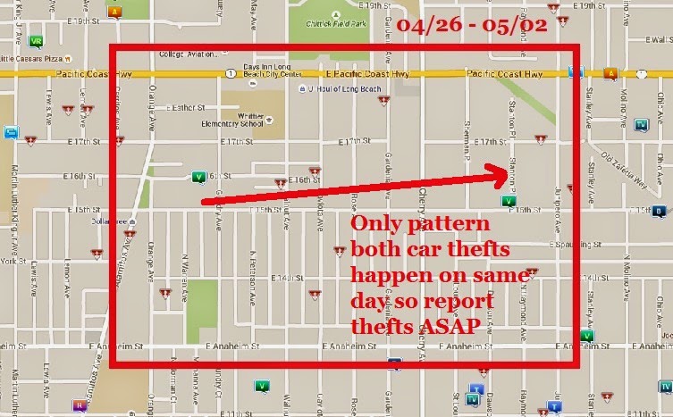
Last Week's Break Down (04/26 - 05/02): Two car thefts took place in our neighborhood. So the only pattern for the week of 04/26 is two vehicle thefts. Both of which take place on 17th street or close to 17th street. The first on 16th street is at 8pm and the second is at 10pm on 15th. This is why most articles that tell you how to stop car theft will tell you report it ASAP. 

While you are debating what to do, the car thief may be heading east to steal another car.

Sorry, last Sunday's Safety Update is late. I was playing a Church in Arizona last Sunday and did not have computer access to post. Since next week information repeats this pattern, here's the article on keeping your car safe once more. 


This Week's Break Down (05/03 - 05/09): This week was not as light. There were two auto thefts and two residential burglaries. This map also doesn't show the vandalism that has been taking place all week at 1732 15th street either. When the graffiti appears it's a reliable sign crime is about to increase. 

* Another pattern to be on the look out for is this. The first night tagging appears, will probably be followed by another night when someone crosses that tagging out and puts their own in its place. And those two events will probably happen within 48 hours of each other.

Notice there is still a pattern of car thefts. I will say, past car thefts have taken place in both of these areas before. Keep a close eye on anything parked on 17th street, Walnut, Rose and when parking by MacArthur Park. 

In addition to the two car thefts, there were two residential burglaries. Time wise, there was no pattern to the burglaries that took place on Warren or Gaviota. The Long Beach PD, has posted numerous articles on crime prevention. Since half the issues in the neighborhood were burglary, here's the Long Beach PD's advice on preventing burglary.

* Also, while neither of these maps is ideal, I will say compared to some of what is going on around it, they are still very encouraging.