Showing posts with label Sunday. Show all posts

Sunday, March 20, 2016

Sunday Safety Watch: 03/13/2016 - 03/19/2016


Disclaimer: So, first I apologize for how long it's taken to get this up, The Crime Reports Website was down for much of January. I did talk to the director of Media Relations at a public safety meeting and tell our neighborhood resource officer, they weren't aware it wasn't updating. Just a reminder these are trends, and the presence of crime in one area in the past doesn't guarantee it will reappear in that area in the future.

Here are this week's trends in the MacArthur Park Neighborhood


Keep an eye along PCH. There were auto thefts that trended west and breaking and enterings that trended East. Also keep your eyes open on Alamitos. Though Alamitos may quiet down when the bike lanes are done. There is increased property damage on Peterson. And there was property damage at Gaviota and Anaheim. The encampment that used to be at Walnut and Anaheim is now there in the alley north of Anaheim. Also notice a trend of thefts at Redondo and PCH. Note virtually everything in that circle took place on Friday.

There was a very suspicious van at Cherry Donuts. Read the details here.

There were three recent shootings outside our neighborhood. Two were officer involved shootings.
The first incident began about 6:30 p.m last Thursday., when officers spotted a vehicle that was "acting in a suspicious and evasive manner" near 68th Street and Long Beach Boulevard, said Marlene Arrona, a spokeswoman for the police department. The car stopped in the middle of Long Beach Boulevard, and a man inside left the car and fled on foot away from police, Arrona said. Officers chased the man about two blocks to an alley near 68th Street and Orcutt Avenue. In the alley, the man allegedly brandished a firearm and did not drop it, Arrona said. After the man was shot, officers provided medical aid and he was later taken to a hospital, where he was pronounced dead, police said. His identity was not released.
A man was killed during a shooting in the city’s West Side early Saturday morning, Long Beach Police Department (LBPD) officials said. Officers were dispatched to the 2300 block of Cameron Street at 2:25AM on Saturday, March 19 regarding a shots heard call, LBPD spokesman Brad Johnson said.  “While responding to the scene they were advised that there was a subject down in the street,” he added. Arriving officers found a man suffering from an apparent gunshot wound to the upper torso, according to officials.

The final shooting was not officer involved: Police are investigating a shooting in North Long Beach that left a woman injured just after midnight Friday, authorities said. An officer was dispatched to a Downey hospital at 1:13AM on Friday, March 18 regarding a gunshot victim who was shot on the 6800 block of Atlantic Avenue, Long Beach Police Department (LBPD) spokesman Brad Johnson said.

Sunday, November 22, 2015

Sunday Safety Update: 11/15/2015 to 11/21/2015


Disclaimer: Please note these maps are meant to show which direction crime is trending, areas to keep an extra eye on and places to remain vigilant in order for Central Long Beach residents to remain safe. That said, previous trends don't guarantee future trends will repeat in the same direction and patterns. Also, an absence of crime in one area, does not guarantee an

Within the borders of the MacArthur Park Neighborhood not much is happening. It's been very quiet around the park itself. And thanks to our neighborhood resource officers, the park itself and the alleys are spotless. When I passed by for today's clean up, the other side of 14th was worse than the park itself.

There is a weak trend of assaults at PCH and Alamitos heading northwest towards fifteen, where a slightly stronger trend of unrelated crimes dips south back into the neighborhood. Be vigilant around PCH and Alamitos by the college and by Alamitos and 15th. Also be very careful if you're in the north end of the neighborhood just to the east of us.

There is a weak trend of car thefts heading from the AOC7 around Hoffman and 11th heading North East towards Gaviota an Anaheim. In that same neighborhood last night at around 10th and Vina, the streets were blocked off and a police helicopter was in the area.  I know due to neighborhood contacts, I have not yet learned the reason. I will share as soon as I do.


Within pour neighborhood there is a lot of activity around Junipero that starts with strong trends heading East or West and weaker trends heading South East or North West. If you're in the area around Anaheim and Junipero, please keep your items locked. There have been increased breaking and enterings, which will get worse as we approach the holidays. Also, there is a strong trend of different kinds of crime around Spaulding Street. Anywhere on Spaulding west of Junipero keep an eye out for your friends and neighbors.

Because I have a few off days, there will be extra neighborhood walks, Go Long Beach Requests, and
Josephine A Villaseñor and I are going to work on a more structured version of a Community Watch that would allow better communication between neighborhoods and better training on conflict deescalation, disaster preparedness and and self defense.


Sunday, September 20, 2015

Sunday Safety Update: 09/13/2015 to 09/19/2015


Disclaimer: Please note these maps are meant to show which direction crime is trending, areas to keep an extra eye on and places to remain vigilant in order for Central Long Beach residents to remain safe. That said, previous trends don't guarantee future trends will repeat in the same direction and patterns. Also, an absence of crime in one area, does not guarantee an absence in that same area later on. as well. 

09/13/2015 - 09/18/2015: This map looks really good overall. There is a few things going on outside the neighborhood. There are some random scattered activity outside the neighborhood border. The most obvious is on the other side of Alamitos and 17th. Since there have been two shootings in this area, keep your eye open here, be safe and stay observant. There is a weak trend showing that activity trending north east.

A lot that the map does not show is also way down. The neighborhood is seeing less dumping, less tagging and less loitering in places where the loitering had gotten way out of hand. As a matter of fact, some tagging, that had been up for up to six months, because it was somewhat hard to get to, also came down this week.

At Walnut and Anaheim, there was a burglary and a theft. It appears that is also trending north east towards Cherry and 14th. There are also a string of vehicle related crimes that start around Stanley and 11th. This is in an area defined on Next Door as Cambodia Town East. They appear to be trending South East, but keep cars locked in the south east end of the MacArthur Park Neighborhood, that could change any time.

I am still working on creating an unsolved violent crimes page, so that no victim of a violent crime in this Central Long Beach becomes a statistic instead of a name.

In Long Beach itself, there have been no further shootings and violent crimes outside of our neighborhood since the last update. I am hoping for that trend to continue. Hopefully, we get a few more maps as empty of incident as this one in the weeks to come.

Thursday, August 13, 2015

Sunday Safety Update: 07/19/2015 to 08/08/2015

Please note these maps are meant to show which direction crime is trending, areas to keep an extra eye on and places to remain vigilant in order for Central Long Beach residents to remain safe. That said, previous trends don't guarantee future trends in the same direction. This is a combination of three maps for the week of 07-19-2015 all the way until 08-08-2015. They will all show pretty much the same thing. Be very cautious around the U-Hail Station on PCH, Rotary Centennial Park and the southern end of MacArthur Park. There is a recurring trend of assaults around MacArthur Park and there is a recurring trend of thefts, especially car thefts around Rotary Centennial Park and Rosa Park's Park by the Dollar Tree.


Earlier maps, which span 07/19/2015 to 07/25/2015, showed most activity of this week on the outskirts of the neighborhood. Notice there is still a trend of car thefts just south of Rotary Centennial Park leading from Sherman both North West and North East. Also notice a similar trend of car thefts starting around MacArthur Park and Raynond that trend south and converge around Gaviota and 11th. Keep this in mind because something major will happen on Gaviota and 10th in only four weeks.


There is also a trend of thefts that move south from 18th Street and move south towards Rosa Parks Park. Also, the loitering on 17th Street has continued despite the violence that happened on both sides of Orange on 17th Street, someone in city government is encouraging and defending it..

In the following week, 07/26/2015 to 08/01/2015, the car thefts around Rotary Centennial Park die down, however they don't stop as there is still on one Sherman north of 17th Street. There is minor trend of robberies around MacArthur Park that move south west into the AOC7 neighborhood. Also notice all the incidents on PCH trend the same direction as they did the previous week. That is absolutely normal whenever something happens on PCH.


Just last week, 08/02/2015 to 08/08/2015, you see property crime that starts on Peterson and trends south. Peterson is usually tagged on the west side of the street and it usually happens to an un-monitored part or Fire Station 10. You will also notice there is a similar pattern of assaults along the south end of MacArthur Park trending east along Anaheim. You wiill also notice there was a theft from a car just south of Rosa Parks Park an then some similar thefts around it, but a little later in the week. All three maps suggest caution around Rosa Park's Park, MacArthur Park and Rotary Centennial Park. Additionally keep your eyes open on Sherman Street since a lot of car thefts start there. At least two maps suggest caution on PCH anywhere near the U-Haul Station.


Sunday, June 28, 2015

Sunday Safety Update: 06/21/2015 - 06/28/2015


Crime is clearly down in MacArthur Park. There are three places you should keep your eye on. Right outside out neighborhood, keep you eye on Altimos Blvd, especially where it crosses PCH. Please do this for two reasons, the first being crime is up along that corridor. The second is that's the corridor that leads north to the neighborhood where the homicide of Alicia Faith Todd took place on 06/24.

Also notice there is a string of thefts and assaults on Anaheim just east of our neighborhood. They do not trend any direction, but keep your eye on the east end on Anaheim, just in case they do begin to trend east.

There was not a lot of tagging this week. The tagging shown on the map is minor and does not cluster anywhere. One trend was predictable. On Wednesday I reported that there was increased crime along PCH. While it doesn't trend either direction if you compare the map on Wednesday to the one released today you will notice, that the number of incidents has nearly doubled along PCH.


The top map represents crime through Wednesday along PCH. The bottom is crime through Sunday. Notice how both the number of overall incidents doubles as does the number of specific types. For instance, by Wed along Altimos we have two car thefts. By Sunday, we have another one and someone stealing from a car as well as a theft along Anaheim just outside our neighborhood. In other words if you see crime increase in a specific area, keep your eye on that area. 

Right now, especially keep an eye on Altimos and PCH.

Sunday, June 21, 2015

Sunday Safety Update: 06/14/2015 - 06/21/2015

Most of the activity in the MacArthur Park Neighborhood that got reported to the police included were either assaults or property damage. Just like in the past, these incidents trend north East as you get later in the week. This week there was also a lot of tagging along the south side of 15th street. This included the mailbox, light posts, walls and alleys from Gardenia all the way to Walnut. Then it continued down Walnut and showed up a little later on Peterson. All that tagging happened some time Friday evening after 11:30pm.

This is the exact same pattern from the last four maps. Starts central and then tends NE

There was also a problem with fireworks and loitering south of 14th on Walnut. There is a tremendous loitering problem there which tends to devolve into tagging at least every two weeks. When I say loitering, I mean an excess of often twenty people in the street doing things like setting off fireworks. For now keep an eye out on 15th between Gardenia and Walnut. Also keep an eye on Walnut south of 15th. Prediction: 1501 14th street will be the target of vandalism next, since it is usually tagged after Peterson and 15th get hit. There was also a trend of auto and bike thefts that begin just outside our neighborhood. 


The Sunday safety update, Be careful in the area of 15th to 14th and Gardenia to Walnut. This is where virtually all incidents, reported and unreported, center at. This is also the same pattern as the last three maps. There is a strong possibility that most of the neighborhood tagging starts on the east side of Walnut south of 14th.

Saturday, May 9, 2015

Sunday Safety Update 10 and 11


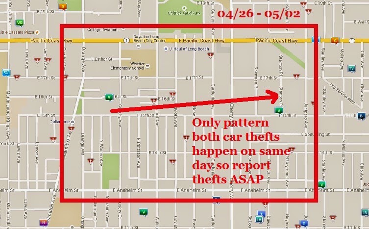
Last Week's Break Down (04/26 - 05/02): Two car thefts took place in our neighborhood. So the only pattern for the week of 04/26 is two vehicle thefts. Both of which take place on 17th street or close to 17th street. The first on 16th street is at 8pm and the second is at 10pm on 15th. This is why most articles that tell you how to stop car theft will tell you report it ASAP. 

While you are debating what to do, the car thief may be heading east to steal another car.

Sorry, last Sunday's Safety Update is late. I was playing a Church in Arizona last Sunday and did not have computer access to post. Since next week information repeats this pattern, here's the article on keeping your car safe once more. 


This Week's Break Down (05/03 - 05/09): This week was not as light. There were two auto thefts and two residential burglaries. This map also doesn't show the vandalism that has been taking place all week at 1732 15th street either. When the graffiti appears it's a reliable sign crime is about to increase. 

* Another pattern to be on the look out for is this. The first night tagging appears, will probably be followed by another night when someone crosses that tagging out and puts their own in its place. And those two events will probably happen within 48 hours of each other.

Notice there is still a pattern of car thefts. I will say, past car thefts have taken place in both of these areas before. Keep a close eye on anything parked on 17th street, Walnut, Rose and when parking by MacArthur Park. 

In addition to the two car thefts, there were two residential burglaries. Time wise, there was no pattern to the burglaries that took place on Warren or Gaviota. The Long Beach PD, has posted numerous articles on crime prevention. Since half the issues in the neighborhood were burglary, here's the Long Beach PD's advice on preventing burglary.

* Also, while neither of these maps is ideal, I will say compared to some of what is going on around it, they are still very encouraging.