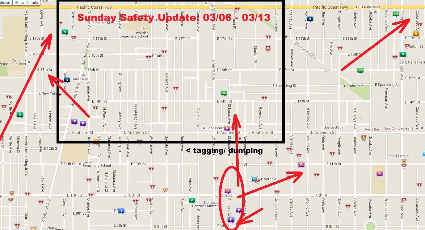
Here are the crime trends for this week in the MacArthur Park Neighborhood. The map is almost empty this week. There was property crime that trends towards some auto thefts, that trend North East towards 17th and Orange. Be careful at the south end of Orange and Anaheim, the property crime is in the same place as an encampment that was just removed. In Cambodia Town East, there were also some property crime along St Louis and 11th that trend up towards St Louis and Anaheim where some assaults took place. The car thefts around Rotary Centennial Park appear to be heading away from the neighborhood this week.
There is a ton of tagging and dumping in an alley that spans Gaviota to Rose. The alley is just behind Anaheim. As part of our Neighborhood Expansion program this week we clean half of that alley and reported all the tagging for clean up. We also did a Go Long Beach Run through our own neighborhood and the AOC7. The AOC7 has a clean up next week.
The map now shows where the dumped items are, so if the city doesn't pick it up before the clean up, AOC7 can just hand that map to Public Works.
There have not been shootings since the last round. However, the one that took place in North Long Beach at Artesia and Butler, now has identified the victim. Authorities Tuesday identified a man killed in a possible gang-related shooting in Long Beach that also left another man wounded. The shooting occurred about 3 p.m. Thursday near Butler Avenue and Artesia Boulevard, said Long Beach police Sgt. Brad Johnson. Tyrone Douglas, 19, of Long Beach died at a hospital, said coroner’s Assistant Chief Ed Winter. We are trying to identify victims, to prevent any shootings in Central Long Beach from being statistics as opposed to names/ real people.
Disclaimer: So, first I apologize for how long it's taken to get this up, The Crime Reports Website was down for much of January. I did talk to the director of Media Relations at a public safety meeting and tell our neighborhood resource officer, they weren't aware it wasn't updating. Just a reminder these are trends, and the presence of crime in one area in the past doesn't guarentee it will reappear in that area in the future.
The map above spans two weeks. You will notice all the patterns are weak, hence the pink lines. The darker the arrow, the stronger the trend. First off, not much is happening according to the map in February. It does appear assaults and property crime [graffiti] are on the rise. They seem to weekly trend up from Cherry towards 14th Street and Gundry. Josie and I did a patrol through the neighborhood pretty late into the night, and it was rather quiet.
A Go Long Beach Run through the area showed Gang tagging is up. In response, we hit several areas outside the neighborhood with Go Long Beach. We also used Code Enforcement with businesses that refuse to take the tagging down. - See the Neighborhood Expansion Report Below
There is also a week trend of assorted crimes along Spaulding in the East end of the MacArthur Park Neighborhood of Central Long Beach. There is also a trend of thefts along Alamitos. Bear in mind the construction on Alamitos around Rosa Parks Park gives bad people a place to hide. When walking along Alamitos, please carry a flash light and walk in pairs when possible.
Neighborhood Expansion: Heavy tagging by the East Side Longos, a tagging crew and somebody else.
Cedar and Chestnut Streets are the strong hold for the East Side
Longos. I was verbally assaulted by a "gang" member when I was taking
the pictures, didn't scare me. I stood my ground and he backed off. Also
meet Gustavo, his garage has been tagged 6 to 7 times and he repaints
it every time, he knows who does it ,talked with the father of the boy
but the father didn't care. Attention: The post about the tagging I did, the GO Long Beach App had
most of the tagging cleaned up before 12pm today. I want to thank them
for their fast response. So I'm going to try to help him repaint it
and talk with the kid and father.- Josephine Villasenor/ Wrigley Community Watch

The police have released a recap of crime stats last year via the website Next Door: Here's a summary. Total
Part 1 crime increased 15.9% from 2014; violent crime increased 18.8%;
and property crime increased 15.4%. The number of aggravated assaults
increased 18.9%; and 17 of the 36 murders in 2015 were gang-related.
Reductions were seen in four property crime categories: residential
burglary decreased 11%; garage burglary decreased 7.2%; commercial
burglary decreased 12.1%; and arson decreased 8.2%.
The West Division Leadership Forum will be held on 02/24/2016. It will again be held at Grant AME Church at 1129 Alamitos Ave, at 6pm. The subject will be preventing auto theft, which we covered in detail here.
Sorry, I'm a day late.
Disclaimer: Please
note these maps are meant to show which direction crime is trending,
areas to keep an extra eye on and places to remain vigilant in order for
Central Long Beach residents to remain safe. That said, previous trends
don't guarantee future trends will repeat in the same direction and
patterns. Also, an absence of crime in one area, does not guarantee an
absence in that same area later on. as well.
The first thing you should notice is there is a trend of car thefts east of Rotary Centennial Park and Orizaba Park. From each park, the thefts trend along Old Zaferia Way, west and towards the center. If this pattern continues, this map will look very similar next week, except the car thefts will be on the west side of Old Zaferia Way. Please reread how to protect yourself from car thefts, if you live in that affected area. This trend was predicted last week.
There is also a trend of of various criminal activity from the south east corner of Anaheim and Junipero leading north west. This pattern is much less concrete, but please keep eyes open along Sherman and 14th as well of all of Spaulding Street just in case.
Finally, there is a trend of thefts and robberies that lead along the Northern end of MacArthur Park and trend South East towards the AOC7 and Mahanna. Always keep your eyes open along the south end of MacArthur Park as it is consistently a problem area. Also notice there is a trend of assaults that starts at the alleyway just north of Anaheim Street and Walnut then trends South West. Because there is a tremendous amount of loitering at that plaza south of that alley, please keep your eyes open in that area and be safe.
Neighborhood Expansion is still on, for another week due to the following shooting. Police
on Monday investigated the circumstances surrounding the shooting death
of a 23-year-old man in Long Beach. The man, identified by coroner’s
Assistant Chief Ed Winter as
23-year-old Long Beach resident Andre Berero, was pronounced dead at a
local hospital. Read the full write up here. As
part of that expansion, we sent in 28 Go Long Beach Requests for the
area, patrolled the area at night and cleaned up 11th Street from Walnut
to Cerritos.
The following major incident took place well outside our borders, but everyone should be aware of it. Long Beach police are investigating a nonfatal shooting in Willmore City and stabbing in Downtown Long Beach that occurred last Friday. Police think the shooting and stabbing might be related. The shooting was at the 1000 block of Virginia Court; the stabbing was at the 1000 block of Pine. Both of these addresses are about at tenth street and less than a third of a mile from each other.
Read the Press Telegram write up here.
Also don't forget. we're trying to identify this person of interest in a June homicide of Iran Maese.
Please note these maps are meant to show which direction crime is trending, areas to keep an extra eye on and places to remain vigilant in order for Central Long Beach residents to remain safe. That said, previous trends don't guarantee future trends in the same direction. This is a combination of three maps for the week of 07-19-2015 all the way until 08-08-2015. They will all show pretty much the same thing. Be very cautious around the U-Hail Station on PCH, Rotary Centennial Park and the southern end of MacArthur Park. There is a recurring trend of assaults around MacArthur Park and there is a recurring trend of thefts, especially car thefts around Rotary Centennial Park and Rosa Park's Park by the Dollar Tree.

Earlier maps, which span 07/19/2015 to 07/25/2015, showed most activity of this week on the outskirts of the neighborhood. Notice there is still a trend of car thefts just south of Rotary Centennial Park leading from Sherman both North West and North East. Also notice a similar trend of car thefts starting around MacArthur Park and Raynond that trend south and converge around Gaviota and 11th. Keep this in mind because something major will happen on Gaviota and 10th in only four weeks.
There is also a trend of thefts that move south from 18th Street and move south towards Rosa Parks Park. Also, the loitering on 17th Street has continued despite the violence that happened on both sides of Orange on 17th Street, someone in city government is encouraging and defending it..
In the following week, 07/26/2015 to 08/01/2015, the car thefts around Rotary Centennial Park die down, however they don't stop as there is still on one Sherman north of 17th Street. There is minor trend of robberies around MacArthur Park that move south west into the AOC7 neighborhood. Also notice all the incidents on PCH trend the same direction as they did the previous week. That is absolutely normal whenever something happens on PCH.
Just last week, 08/02/2015 to 08/08/2015, you see property crime that starts on Peterson and trends south. Peterson is usually tagged on the west side of the street and it usually happens to an un-monitored part or Fire Station 10. You will also notice there is a similar pattern of assaults along the south end of MacArthur Park trending east along Anaheim. You wiill also notice there was a theft from a car just south of Rosa Parks Park an then some similar thefts around it, but a little later in the week. All three maps suggest caution around Rosa Park's Park, MacArthur Park and Rotary Centennial Park. Additionally keep your eyes open on Sherman Street since a lot of car thefts start there. At least two maps suggest caution on PCH anywhere near the U-Haul Station.