This is a blog for the MacArthur Park Community. Its purpose is to improve neighborhood safety, business and keep the community clean.
Sunday, September 27, 2015
Sunday Safety Update 09/20/2015 - 09/27/2015
Disclaimer: Please note these maps are meant to show which direction crime is trending, areas to keep an extra eye on and places to remain vigilant in order for Central Long Beach residents to remain safe. That said, previous trends don't guarantee future trends will repeat in the same direction and patterns. Also, an absence of crime in one area, does not guarantee an absence in that same area later on. as well.
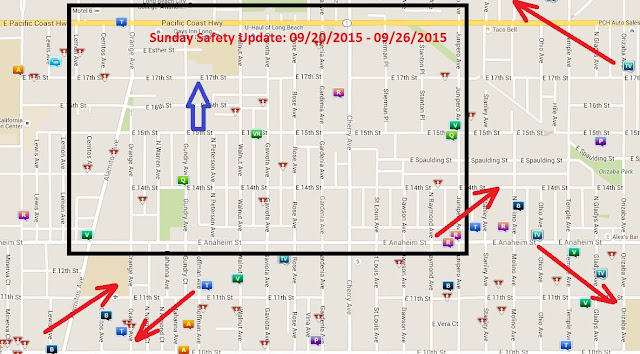
09/20/2015 - 09/27/2015: Inside the MacArthur Park Neighborhood the map looks good. I am most concerned with what I see inside the AOC7, Cambodia Town East and the Zaferia Neighborhood to the east of Old Zaferia Way. First off, here's what the map shows. Within out neighborhood, the most concerning robbery trend starts at Anaheim and Junipero and seems to trend northeast and out of the neighborhood. What concerns me even more is the trend of car thefts, and thefts from vehicles heading southeast, right where that trend ends.
Normally, I would declare neighborhood expansion and start attacking the graffiti in Cambodia Town East where that activity is the worst, but the online version of Go Long Beach is broken since the last city website update. So far, every single district and the Mayor of Long Beach has not responded to the information that is website doesn't work.
I have contacted every city agency I can think of, the website developer and posted on the Long Beach City Facebook Page.
Within the AOC7 there are some thefts and assaults clearly trending south west. There are a few burglaries to the west of that that seem to be trending the opposite direction. Keep a very close eye on the west end of the AOC7 and the Craftsman Historic District. This is right about where Lincoln Elementary is. There is no neighborhood association in this area. Also there was a fatal shooting in exactly this area about a month ago.
Within our neighborhood, there is no clear pattern and nothing is really clustering together. The "Q" was for a drug bust on the outskirts of MacArthur Park. There was also an isolated car theft at Anaheim and Alamitos. There is also one isolated robbery just north of Cherry and 15th. The map doesn't show this but there was tagging along Orange and Cherry Ave, after a long tagging hiatus. That tagging is a little harder to remove with Go Long Beach broken.
The most obvious activity is along Junipero at the east end of the neighborhood. That said, it seems mostly to be trending away from the MacArthur Park Neighborhood. Finally, where you see that blue arrow, keep your bikes locked up. I will go into detail later, after passing the information on to law enforcement.
Labels:
activity,
Andrews,
California,
crime,
criminal,
Dee,
District,
Long Beach,
MacArthur,
park,
six,
Trends
Location:
Long Beach, CA, USA
Subscribe to:
Post Comments (Atom)


No comments:
Post a Comment